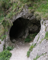
The proponents of the Limited Tehuantepec Theory of Book of Mormon geography have suggested that a mountain in the southeastern part of the state of Veracruz might be the original Hill Cumorah. This mountain goes by the name of Cerro Vigia, (or Lookout Hill). For those users of Google Earth who would like to investigate it up close, the coordinates are 18 25’ 25.82” N, 95 20’ 59.08” W. This mountain is about 70 miles WNW of the Isthmus of Tehuantepec, which they have proposed is the “narrow neck of land” mentioned in the Book of Mormon. Disregarding all the other problems with the Limited Tehuantepec Theory[1], let us consider this mountain based solely on the criteria for the Hill Cumorah listed or suggested in the Book of Mormon. Cerro Vigia is an isolated part of the Tuxtla Mountain chain near the Gulf of Mexico. It is 2700 feet in elevation, rising 1500 feet above the surrounding farmland. Vigia is an extinct volcano composed of eroded basaltic lava flows.[2] It is sporadically covered with semi-tropical vegetation and much of it has been clear for farming, some of the plots extending almost to the crest.
[1] For a full treatment refer to http://www.mormongeography.com/tehuantepec-theory.html
Several archaeological studies have been completed on the area including the most recent one that was a archaeological survey of the entire surrounding area[3] These studies have determines that:
The area was continuously occupied from mid formative times (900 BC) to the Postclassic (1000-1421 AD). There were a number of major habitation sites nearby or within 5-10 kms. of Vigia.
The ceramic artifacts vastly outnumber the lithic (stone) ones. For example at the site of Totógal 27,000 ceramic artifacts were recovered, compared to 457 stone ones.
All obsidian at the sites would have been imported.
What does this data tell us?
1. There is no archaeological evidence that this was a battleground in 385 AD, otherwise there would have been substantially more lithic artifacts, arrow points, etc. as well as evidence of burned habitations and buildings.
2. The Book of Mormon gives the impression that the Cumorah area was an uninhabited region. This is certainly not the case with Vigia. It was continuously occupied early on until the conquest and there is no evidence that there was a depopulation at any time around 385 AD.
3. There should have been evidence of abundant stone weaponry (i.e. arrow points, knives, axes, etc.) but this was not the case, the ceramic artifacts vastly outnumber the stone ones indicating habitation sites and not battle zones.
4. All the obsidian, which could have been used for weaponry, would have been imported. Mormon said he went to Cumorah to gain an advantage over their enemies (see Morm. 6:4). There would have been no advantage as far as weaponry was concerned if all obsidian had to be brought in.
In addition, there are other problems with the Vigia proposal.
1. As the mountain is composed of basalt, there is a lesser likelihood that there would be natural caves in the area that would have been appropriate for the storage of records.
2. The mountain itself is not unusual for “waters, rivers and fountains” as Mormon described it (Morm. 6:4).
3. There is no evidence of fortifications or large, short term, habitation sites.
4. And finally, Cerro Vigia is near (about 6 miles to the east of) the major Olmec center of Tres Zapotes. This site spanned the period 1000 BC to 900 AD. It was not only not annihilated during the Jaredite wars about 400 BC (which would have been the case had Vigia really been Ramah), but flourished on until 900 AD, long after the other Olmec sites had been abandoned. In view of the above I think we can safely say that Cerro Vigia is not the Hill Cumorah.
[1] For a full treatment refer to http://www.mormongeography.com/tehuantepec-theory.html
[2] Geology of the Tuxtla Volcanic Field. Nelson and Gonzalez. Volcanology, 1992, #55, p.85-96.
[3] Tepango Valley Archaeological Survey: Tuxtla Mountains, Southern Veracruz, México FAMSI 2008 by Wesley Stoner.
No comments:
Post a Comment