 |
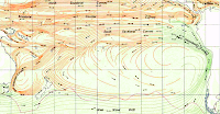
| Southern Pacific Ocean currents showing the Equatorial Counter Current Click to enlarge |
In 1990 David Clark (1) suggested that Lehi may have crossed the Pacific Ocean, on his voyage from the middle east to the Americas, utilizing the Equatorial Counter Current. This current flows eastward from Indonesia, and is sandwiched between the the two major westward moving equatorial ocean currents (the North and South Equatorial Currents respectively). This current is normally fairly weak, but during periods when the El Nino effect is manifest, it is magnified and becomes a significant, eastbound current (see illustration below). John Sorenson picked up on this suggestion and used it to explain Lehi's arrival on the coasts of Mesoamerica, in line with his Tehuantepec theory.
The other day I made an interesting discovery relating to this topic. I had been re-reading Thor Heyerdahl's Kon Tiki and decided to do an overview of the Pacific Ocean currents.
Checking the search results on the “Pacific Equatorial Counter Current” I found that this current normally flows east between the equator and five degrees north, and more importantly, is very pronounced during the El Nino years. It travels at speeds of from .5 to 1.3 miles per hour. The surface above the current is commonly known as the “doldrums” as the wind above the current is non-existant, or unpredictable. It funnels water from the relatively hotter western seas, to the cooler eastern ones. It follows a very slight downhill gradient as the western sea level near Indonesia is about 18 inches higher than the eastern sea level on the shores of the new world.
Is this relevant to Book of Mormon geography? Yes, indeed! It means that there was a possible route for Lehi and his party to travel eastward across the Pacific. Using the Liahona, the Lord could have guided them precisely on this route. The lack of wind in the doldrums is a little problematic, but even without wind, they could have floated with the current at about 24 miles per day. And there are periodic storms in this area which would have filled their sails, even if briefly.
The only other eastward routes would be following the northern current clear up by Japan and then southward along the coast of Alaska and North America. Or on the other exteme, southward with the South Pacific Current down past Australia, through the cold and turbulent seas near the Antartcic Circle and then up the coast of South America. I don't believe either of these latter options would have been feasible.
I have observed one other very interesting point during this exercise. As mentioned above, the Pacific Equatorial Counter Current occurs between the equator (0 degrees) and 5 degrees north. This brackets Central and South America from northern Ecuador to Panama. It does not extend to 20 degrees north which is the latitude of John Sorenson's proposed landing place in Mesoamaerica.
As the Equatorial Counter Current abuts against the American landmass, it splits and branches into a south and a north reversing curve. These hairpin curves bend around to the west and join the North and South Equatorial Currents flowing westward.
In the area of Mesoamerica, the ocean currents flow southward to join the North Equatorial Current. Thus it would have been difficult for the Lehites to arrive in Mesoamaerica using the counter current because from 5 or 10 degrees north they would have been sailing against a prevailing current. However it would have been relatively easy for them to disembark in southwestern Costa Rica, my suggested area for their landing.
In the area of Mesoamerica, the ocean currents flow southward to join the North Equatorial Current. Thus it would have been difficult for the Lehites to arrive in Mesoamaerica using the counter current because from 5 or 10 degrees north they would have been sailing against a prevailing current. However it would have been relatively easy for them to disembark in southwestern Costa Rica, my suggested area for their landing.
 |
| The blue band flowing from left to right is the counter current. Notice that it abuts Costa Rica and Nicaragua at its east end. |
The illustration at the left shows the different ocean currents in color. The landmass is black. Blue indicates the eastward moving currents, yellow the westward, red the northward, and green the southward. This chart was generated from a NASA sponsored site (http://oceanmotion.org/html/resources/oscar.htm) and depicts the currents as of December, 1998. This was the strongest El Nino year recorded up to this time. As can be seen, the blue Equatorial Counter Current flows right to Costa Rica.
(1) Lehi and El Nino. David Clark. BYU Studies 30:3 (1990) http://byustudies.byu.edu/PDFLibrary/30.3ClarkLehi-e27079ad-71a0-4100-b12c-347eb60dc3ba.pdf
