Walking Across the Narrow Neck
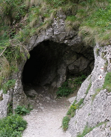
Last week I walked across the Book of Mormon's "Narrow Neck of Land". It took me 6 ½ hours to walk from the sea east to the sea west. The Book of Mormon reports that a Nephite could do it in a day. I was ready to call it a day when I had finished. I am not used to walking 20 kilometers.
The place I consider to be the Narrow Neck of Land is located in Nicaragua, more precisely the Isthmus of Rivas between the Pacific Ocean and Lake Nicaragua. (For further details check web page). I believe this is the only isthmus in the western hemisphere that matches the description in the Mormon scripture. This "narrow neck" feature is the key to identifying Book of Mormon geography and locating Nephite lands. Many other geographies have been proposed but none that I can find has an identifiable, rational "narrow neck of land" trending in a "northward" direction and bordered by two bodies of water.
This "narrow neck" should be traversable in 12 hours or a normal day. It should be remembered that the Nephites did not travel at night even when pursuing, or being pursued, by their enemies, so it is not legitimate to suggest a 24 hour day.
I challenge those espousing other theories to prove them by actually walking across their proposed "narrow necks" in a day. The Isthmus of Tehuantepec in Mexico, the "narrow neck" of one of the proposed theories, would take at least four days to cross on foot. The Isthmus of Panama, which was the route of some of the "forty-niners" traveling to the California goldfields, required three days to cross. If the geography is incorrect, the archaeology is irrelevant, no matter how impressive.
Your reading is inaccurate:
ReplyDelete1. The "line bountiful" was 1.5 days wide, the narrow neck was not that wide.
2. It was a flat, straight plain for 1.5 days distance.
There is nothing in either central or south america that meets that criteria.
There were two measurements of the Narrow Neck. One, as you mention, was 1.5 days travel across. The other, mentioned in Hel. 4:7, was one days journey across. This could have been the same place with different interpretations of distance. However I feel that they were two different locations on the Narrow Neck. The first being the distance from the Bay of Hogath (Bay of Salinas) to the East Sea (in this case Lake Nicaragua), and the other being the shortest distance across the isthmus which today is covered by the highway from La Virgen to San Juan del Sur. The first measures approximately 18-20 miles, the second 12 miles.
ReplyDelete"Neck" is inferred but not stated. The "Line Bountiful" was "1.5 days wide" NOT the narrow neck, pass, or passage.
ReplyDeleteThe second reference only refers to "the line they had fortified."
In any case, 1.5 or 1 days distance was not perceived by Mormon as something "narrow" capable of being blocked by snakes.
Whatever you believe the "line bountiful" to be, it must be flat.
The area I visualize as the Narrow Neck is fairly flat. But I would be interested in knowing where you find a reference indicating it had to be flat.
ReplyDeleteI like what you wrote about actually walking across the area you believe to be the narrow neck. I've been reading path between the seas about the panama canal, and many people who wanted to build a canal just made estimates about certain things in panama and costa rica, but when someone actually went and walked the land themselves, things were very different. Also David McCullough refers to that very spot (the isthmus of rivas) as "a narrow neck of land".
ReplyDeletePerhaps the Isthmus of Rivas could have been somewhat wider during BOM times. If Lake Nicaragua had been much deeper during BOM times that would mean a greater area of coast line around the lake. (Making the Isthmus of Rivas perhaps twice as wide.) Now considering that Lake Nicaragua is very silty (brown water), and that over a couple thousand years of gradually filling in... what would that do? Filling the lake with silt and making the depth much shallower would push the water upward, causing the water to cover over existing shore line making the Isthmus of Rivas narrower. The same amount of water with a shallower bottom would create a lake that covers a greater area. The lake is expanding as it fills in. So, the narrow neck of land may not have been so narrow (in ancient times) as it is today.
Delete